by Veronica Combs in Artificial Intelligence on October 28, 2021, 5:47 AM PST

Tactile Mobility added $27 million to its bank account to expand its virtual sensing technology designed to improve car performance and safety. The company announced Wednesday that the new money is part of a Series C funding round led by Delek Motors, with strategic investment from Goodyear Ventures and Porsche Ventures.
The company said in a press release that the funds will be used to expand into new segments among vehicle manufacturers, tier 1 automotive suppliers, insurers and tire manufacturers and to build more virtual sensors and expand the company’s cloud platform.
Tactile works with road authorities and municipalities in the U.K., Germany, Israel, Singapore and U.S. The company also partners with car manufacturers including BMW to provide their next generation vehicles with the sense of “touch.”
Abhijit Ganguly, managing director, Goodyear Ventures, said in a press release that tire data is key to improved safety and efficiency of connected and autonomous driving.
“Tactile Mobility is at the forefront solving this need with their unique, software-only solution and we look forward to working together to bring this technology to vehicles and help to create safer and more efficient travel.”
Yagil Tzur, vice president of products at Tactile Mobility, said the company’s technology allows a car to understand the surface of the road, including factors such as impact and changes to the surface such as light rain or heavy rain.
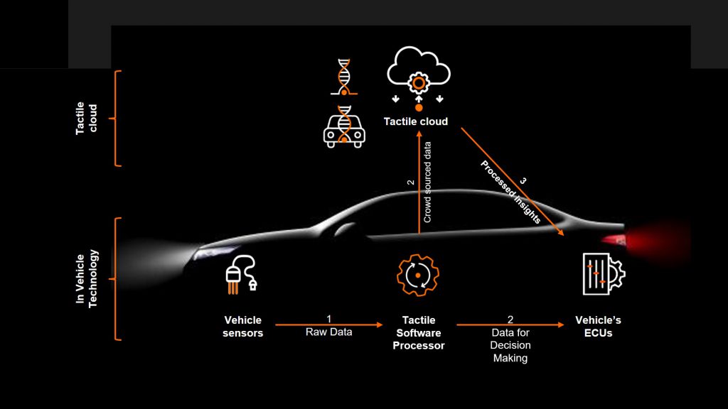
“We take signals from existing sensors in the vehicle such as steering angle, wheel speed, wheel angle and engine torque and run it through a machine learning algorithm to create virtual sensors,” he said.
The virtual sensors can sense tire health, estimate the grip between the tire and the road and predict the risk of hydroplaning. Tzur said the virtual sensors generate two data layers:
- Surface DNA: This is a digital twin of road segments and can understand potholes and cracks as well as how the surface will react to weather conditions such as snow and rain
- Vehicle DNA: This is a digital twin of the vehicle chassis systems, including tires and steering
Understanding and analyzing this data increases the safety of the car as well as the performance and comfort of a vehicle, Tzur said.
BMW uses Tactile’s technology in its cars and the company recently announced an investment from Porsche as well. BMW cars use the data from Tactile’s virtual sensors to shorten braking distance and tune the car’s active suspension system.
Tactile’s vision for the future is using data from these virtual sensors in millions of cars to monitor road conditions and alert drivers to hazards.
“Our vision is that the software comes with the vehicle and is installed in the production line as a standard part of the vehicle,” he said. “At that point, you’ll have millions of cars hitting the road globally and generating data at a high frequency.”
Building privacy protections into data collection
The company has locations in the U.S., Germany and Israel and has about 50 employees, mostly engineers, software developers and researchers. This international focus may be part of the reason the company has factored GDPR concerns into the data collection process.
Tzur said the company classifies the data collection into two categories: information that must be GDPR compliant and and other data that does not require consent to be collected.
“We do not disclose anything about you as a driver or as a owner and the data is uploaded without any vehicle ID,” he said. “Also we look at data in chunks of 15 kilometers, so you won’t be able to see a long drive of 200 miles and be able to associate that with an individual.”
Tactile sensors also don’t record the first minutes or the last minutes of a trip or the vehicle speed.
Tzur said future types of data may need consent to be collected.
“A lot of this data is relevant to fleets where consent will not be an issue,” he said.
Modernizing the monitoring of road conditions
Tactile also has worked with cities to use this data to monitor road conditions in real-time. One project included the city of Detroit and Ford. The city added Tactile’s technology to Ford vehicles to create maps of city roads and rate the health of the pavement.
The city used this detailed and up-to-date data to optimize maintenance budgets and understand which areas need the most attention, Tzur said.
Tactile also has worked with cities to grade potholes. The same vehicles used to monitor road conditions mapped the potholes and created a priority list for repairs. Tactile compared its pothole map to one created by the state road department using traditional survey methods.
“This showed a high correlation between the maps and proved the tech was working as expected and could replace outdated tech that there is today,” he said.
The company is working on a dashboard for city street departments for real-time monitoring of road conditions.
“For larger cities, our API will allow them to take the data into a GIS system and display it as a data layer,” he said.
Tzur said that the company’s data analysis goes through a carmaker’s backend servers and does not interact directly with the car.
Using AI to assess roads in Philadelphia
Using data and virtual sensors is not the only way to monitor road conditions. Philadelphia’s smart cities team collected data from cameras mounted on the hoods of city fleet vehicles and used AI to analyze the images.
During the pilot, the vendor inspected 1,200 miles of the city’s road network using cameras. The images were then uploaded to be inspected using artificial intelligence that can identify and categorize road faults. The vendor, GoodRoads, had already developed AI recognition of many common road faults, and used the pilot project to train the algorithm to spot potholes, manhole covers, faded pavement markings and regulatory signs.
Emily Yates, Smart Cities Director for Philadelphia, and Joanna Hecht, a Pitch and Pilot Fellow with the city, said they hope to expand the project.
“If funding permits, we would like to be able to routinely inspect all 2,400+ miles of city streets using these vehicle-mounted cameras and city-owned vehicles that regularly traverse the city,” Yates said.
The pilot project gave the city a more comprehensive look at the condition of the city’s streets than was available previously. Yates said that the ability to map various assets and have a quantitative understanding of road conditions allows the city to better respond to citizen concerns.
“By expanding the volume of data collection in a given year, we can better plan for upcoming repairs, more closely align with the Capital Budgeting process and ensure that capital investments are being made equitably throughout the city,” she said.
The city also is considering how to use this technology to collect data around litter, quality of sidewalks and curbs as well as other components of interest in the right of way.

Originally posted in TechRepublic


